Agrofirm, Resort & Hotel Master Planning Survey
Planning to develop an agrofirm, eco-resort, or hotel? Before a single stone is laid, the most important step is understanding the land itself. A Master Planning Survey provides the technical foundation for safe construction, efficient land use, and long-term growth.
Whether you’re designing a luxury retreat, an agricultural hub, or a hospitality property, a proper survey ensures that every decision is backed by accurate data and smart planning.
What Is a Master Planning Survey?
A Master Planning Survey is a comprehensive land assessment that collects spatial, environmental, and infrastructural data needed for large-scale development. It helps architects, planners, engineers, and investors visualize and design the project with precision.
It covers everything from the ground surface and natural terrain to legal parcel boundaries, environmental constraints, and future expansion possibilities.
Key Components of the Survey
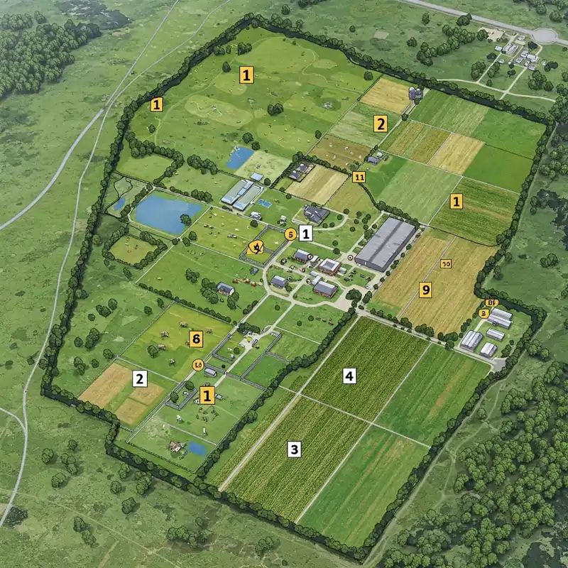
- Topographic Survey
This maps the natural and man-made features of the land including:
- Elevation levels
- Contours & slopes
- Rivers, streams & water bodies
- Existing roads, buildings & utilities
A topo survey helps determine where structures can be safely built, how water flows across the site, and which areas need earthwork.
- Boundary & Parcel Mapping
Accurate land ownership data is crucial. This includes:
- Boundary verification as per government maps
- Plot area calculation
- Parcel adjustments or corrections
- Avoiding disputes during construction
This step ensures that planning is done within legally verified limits.
- Land Suitability & Zoning Assessment
Not every part of the land is ideal for every activity. This assessment identifies:
- Agricultural zones
- Accommodation zones
- Recreational & open spaces
- Utility & service areas
- Hazard-prone or sensitive zones
Proper zoning makes the development more functional, safe, and sustainable.
- Soil & Environmental Analysis
For agrofarms, resorts, and eco-properties, environmental compatibility is essential. The survey may include:
- Soil testing
- Vegetation mapping
- Slope stability study
- Flood and erosion-prone areas
This helps designers ensure minimum environmental impact and maximum land productivity.
- Infrastructure & Utility Survey
A critical part of planning is identifying existing and future service points:
- Water sources & groundwater assessment
- Drainage & natural water flow
- Access roads & internal circulation
- Electricity routes & transformer placement
- Waste management zones
These details help in optimizing lifetime operational costs.
- 3D Mapping, GIS Analysis & Layout Planning
Modern tools like GIS, drone surveys, LIDAR, and 3D surface modeling enhance planning accuracy.
They create:
- 3D terrain models
- Digital elevation maps
- Site layout base maps
- Concept master plans
Architects and planners use these datasets to create visually accurate and technically sound designs.
Why a Master Planning Survey Matters
A well-executed survey:
Prevents costly mistakes during construction
Identifies risks before development begins
Helps in obtaining permits and approvals
Ensures smooth coordination between architects, engineers, and contractors
Maximizes land potential through smart utilization
Supports future expansion with minimal disruption

Perfect for a Wide Range of Projects
This type of survey is ideal for:
-
Agrofarms & integrated farming projects
-
Eco-resorts & wellness retreats
-
Hotels, villas & hospitality properties
-
Farmstay developments
-
Agricultural + tourism combination projects
-
Large land estates and recreational parks
A Master Planning Survey is not just a formality it’s the backbone of any successful land development project. Whether you’re building a serene resort in nature or a modern agro-industrial firm, the right survey ensures your vision becomes a sustainable, efficient, and future-ready reality.